
Newton Abbot Walks, Parks and Nature Reserves
Parks | Nature ReservesThere are a variety of interesting walks near Newton Abbot; some are located within a short walking distance of the town center and many have good accessibility for wheelchairs. It may be of use to view the page on Bridges as this may assist in directions. The following suggests some places to walk for getting out and about in and near Newton Abbot.
Walks
Town Quay to Hackney Marshes
From Newton Abbot Town Quay use the new Town Quay foot and cycle bridge to cross the River Teign.
On the Hackney Marsh side of the bridge are some metal sculpture figures created by Katy & Nick Hallett depicting Dr. Ivy Williams, born in Newton Abbot who became England's first female barrister in 1921; Isambard Kingdom Brunel, who brought the South Devon Railway to Newton Abbot in 1846 and a clay clutter who represents the ball clay industry which began in about 1729 and to this day is a major local business.
Continue following the footpath and pass under the last stone arch section of the main line railwayand walk past the race course into Hackney Marshes nature reserve. You can walk in a loop and return the same way. There is also a footpath following the River Teign under the A380 road bridge to the Passage House Pub.
This walk is on the level with good wheelchair and buggie access. The section alongside the river is narrower, sometimes muddy and more bumpy, but still on the level. Bird watchers can look for little egrets on the River Teign.
Town Quay to Wharf Road Sidings
A short walk with views of the reed beds. Walk under the main line railway and follow the River Lemon footpath to a metal footbridge. Wharf Road Sidings is on the far side. You can loop aound the section that goes under the Teigngrace railway line. This is a quiet spot where the Whitelake Channel meets the River Teign. The bridge and footpath are not suitable for wheelchairs or buggies as the path is narrow and can get muddy. Please take care as swans do make nests in the reeds in that area and should never be approached.
Town Quay to Wharf Road Sidings and Jetty Marsh Nature Reserve
Walk under the main line railway and follow the River Lemon footpath to a metal footbridge. Cross over the bridge and leave the River Lemon behind you as you walk over to Whitelake Channel. Turn left and follow the channel as far as the main road bridge. At this point use the steps to access the main road and traffic light controlled crossing. Cross the road and enter Jetty Marsh Nature Reserve. The route continues to follow the Whitelake Channel, then diverts as it follows the old Stover Canal before sweeping back to an open grass area and over a small foot and cycle bridge which crosses the Whitelake Channel. At this point you can exit via Jetty Marsh Road.
Town Quay to Bakers Park
This is a level walk of about 1.5 miles minimum.
From the Town Quay walk under the main line rail bridge and follow the footpath alongside the houses near the River Lemon. This exits onto Templars Road where you turn right and meet the Avenue. Use the traffic controlled crossing and turn right, cross over the River lemon and turn left into Marsh Road and follow the river. Pass the Lemon Road stone bridge and enter Cricketfield Car Park still following the river course. Follow the footpath until you reach the car park exit, cross the Albany Street bridge and turn right into Victoria Gardens continuing to follow the river. At this point the river disappears under a road bridge at the junction near Bridge House and Halcyon Car Park. Cross Courtney Street turn right and then immediately left, you will see Halcyon car park on your right. Walk along Sherborne Road towards the multi-storey car park and bus station passing under the multi-storey footbridge and the Indoor Market continuing along Market Street. When you see the Passmore Edwards building housing the town library on your right continue towards Asda shopping supermarket. At this point, the river reappears and you keep following the course of the river passing the footbridge to Asda Car parks and the old Union Bridge.
The footpath now goes under the A382 main road bridge and is adjacent to the river. This walk passes the Bradley Lane Industrial Estate and the Linden Terrace footbridge. At the end, turn left and cross over the footbridge to Bakers Park.
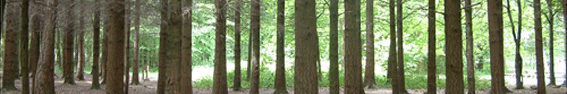
At this point you can choose to walk across Bakers Park to Bradley National Trust land. There are extensive woodlands walks, but you can cross the stone bridge and loop back following the Bradley Leat passing the allotments, then turn right and this will lead you back to the point where you crossed the footbridge into Bakers Park.
The Templar Way
The Templar Way is an 18 mile walk that traces the route by which granite was exported from Dartmoor via the unique Haytor Granite Tramway and the Stover Canal. The Way starts on Haytor and is a downhill walk via Haytor Vale to the Great Plantation at Heathfield, via Stover Country Park on to Locks Bridge at Teigngrace, following the route of the old Stover Canal to Newton Abbot town quay and beyond to Coombe Cellars, Shaldon and Teignmouth. The route is comprehensively waymarked except on the open moor. The last section from the town quay to Teignmouth follows the estuary and therefore should only be attempted within 2 hours of low tide.
This is an extensive walk, but there are shorter sections. Suggest walking from Jetty Marsh towards Teigngrace; a level walk which can get muddy.
Parks
Bakers Park
Bakers Park is located on the western side of Newton Abbot, situated on the A381 Totnes Road with road access via Steppes Meadow. There is a public footpath alongside the River Lemon from Asda to Bakers Park. It should be noted that the section of the River Lemon westwards from Asda is also known as 'Barhams Brook'.
It is a large green field open space suitable for ball games (not golf) with an enclosed childrens play area and free tennis courts.
The adjacent land to the west is owned by the National Trust and is freely accessible for woodland walks. The woodland offers level access
alongside the river and steeper trails to either side.
Bradley Manor is open on specified days
to fee paying public from spring to late summer, so check out the website for more information.
Courtenay Park
Courtenay Park is centrally located in Newton Abbot, situated opposite the Railway Station.
It is an award winning open green space with mature trees and delightful flowering displays. There is an enclosed childrens play area; a sensory garden; a pond; a bandstand and the outdoor bowling green of Newton Abbot Bowling Club
Forde Park
Forde Park is located to the south-east of Courtenay Park. This is a small park offering a level walk with mature trees and tennis courts.
Decoy Country Park
Decoy Country Park is located to the south-east of Newton Abbot. There is car parking, toilets and good access for wheelchairs and buggies.
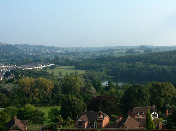
The picture shows the view over Decoy from Wolborough Hill.
The lake was once a clay quarry, but now supports a wealth of wildlife. On three sides of the lake there is woodland, the southern side offers a large level green field play area suitable for ball games (not golf). ` Facilities include an enclosed childrens play area; BMX race track; fishing, sailing, canoeing and a Wildlife discovery Centre.
Stover Country Park
Stover Country Park is located about 3 miles to the north-west of Newton Abbot centre. The entrance to the Park is off the A382 Bovey Tracey to Newton Abbot road 300m south of the Drumbridges roundabout.
Stover Country Park is comprised of about 114 acres of woodland, heathland, grassland, lake and marsh and a substantial variety of wildlife. There is fee paying car parking, toilets, picnic area, visitor centre and Guided Walks along with Family and Children's Events. A great day out for all the family.
Nature Reserves
Churchills Nature Reserve
Located adjacent to Highweek Church on top of a hill. A short walk in a meadow setting with extensive views across Newton Abbot and the Teign Estuary.
Jetty Marsh
Located to the north of Knowles Hill, next to the Whitelake Channel. Jetty Marsh contains a disused canal basin where the old Stover Canal met the Whitelake Channel. The Templer Way, a footpath following the old shipping route from Haytor to Teignmouth, runs through Jetty Marsh and the nearby Wharf Road Sidings.
Jetty Marsh and Wharf Road Sidings are part of the River Teign floodplain and therefore subject to flooding. The close proximity of the Teign Estuary means tidal waters affect this area; the River Lemon in Newton Abbot and River Teign.
The area hosts a mixture of reedbeds, grassland, scrub and mudflats. The site is important for its wildlife, such as reed warbler and Cetti's warbler and is designated as a County Wildlife Site.
The footpath also extends for a longer walk following the Templar Way towards Locks Bridge at Teigngrace. Those who seek more of a challenge can follow the Templar Way to its full extent.
Wharf Road Sidings
Located off The Avenue, an area between the River Teign and the Whitelake Channel and the River Lemon; immediately south of the Newton Abbot racecourse.